

DETECTION AND PROTECTION
Success stories
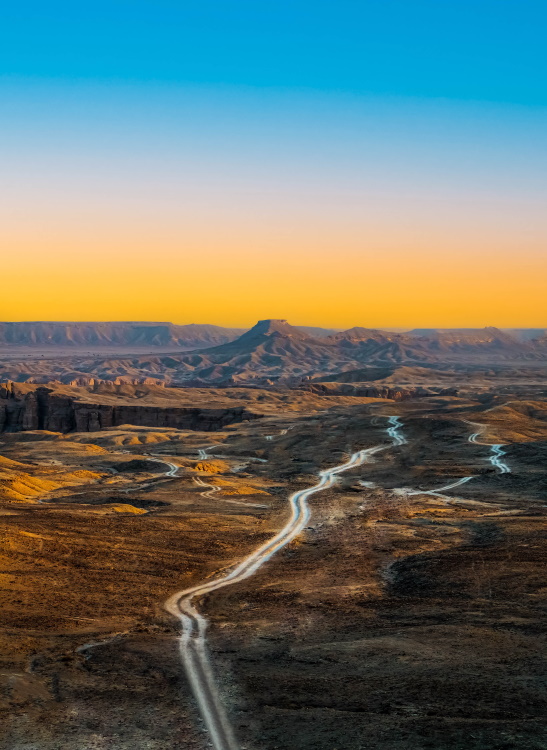
thaah village
The Problem: When Thaah Village complained of land slide events and accumulation of construction debris at the base of a nearby valley, STATERRA was tasked with investigating to pinpoint the source of the land slides. The Solution: STATERRA carried out a thorough investigation that spanned field work and in-house research, and included building additional wells and using drones to track the local topography. Determining the source of debris meant performing hydrology and hydro-geology assessments, tracking ground water table change, analysing the debris material itself, and comparing real-time data to determine if the cause was linked to old construction activities in the area. The Results: With our research done, and modelling with specialised software systems for watershed, hydrology, and hydro-geology, we provided our client with not only the answers they needed, but recommendations – including conceptual engineering designs – on proper restoration and future mitigation of valley erosion.
The Problem: When Thaah Village complained of land slide events and accumulation of construction debris at the base of a nearby valley, STATERRA was tasked with investigating to pinpoint the source of the land slides. The Solution: STATERRA carried out a thorough investigation that spanned field work and in-house research, and included building additional wells and using drones to track the local topography. Determining the source of debris meant performing hydrology and hydro-geology assessments, tracking ground water table change, analysing the debris material itself, and comparing real-time data to determine if the cause was linked to old construction activities in the area. The Results: With our research done, and modelling with specialised software systems for watershed, hydrology, and hydro-geology, we provided our client with not only the answers they needed, but recommendations – including conceptual engineering designs – on proper restoration and future mitigation of valley erosion.
Case
Studies
The diversity of life on Earth is critical to the health of our planet and our personal well-being.
Nature, on the other hand, is under unprecedented stress.
Our demands for food, water, and land, as well as our increasing demand for energy, are destroying habitats, polluting our air and water, and driving animal and plant species to extinction.
Staterra’s goal is to play a significant role in improving the quality of our environment for the benefit of all people while promoting a better understanding of the effects of our society on the long-term health of our planet.
Overview
When Thaah Village complained of land slide events and accumulation of construction debris at the base of a nearby valley, STATERRA was tasked with investigating to pinpoint the source of the land slides.
Hydrological (HEC-HMS) and hydraulic (HEC-RAS) modeling was applied in combination with a detailed analysis of the local hydro-geomorphology for the flood risk assessment and Surface Run off Estimation.
The methodology adopted in this study include our main steps.
1
complete watershed solution
The WMS model was used to extract the drainage networks and basin characteristics.
2
hydrologic modeling program
The HEC-HMS, which has a high capability of calculating hydrograph curves in multiple ways, according to ease of basin drainage, by either natural or artificial methods.
3
hydraulic models
A hydraulic model (HEC-RAS) was used, which has a high capacity for determining the runoff limits, depths, and velocities of flooding.
4
Flood hazard assessment
Spatial modeling (GIS and RS) was used, with a high capacity for linking, identifying, and spatially analyzing areas at risk for flooding in the city, leading to sustainable urban development.
Solution
Process
Staterra carried out a thorough investigation that spanned field work and in-house research, and included building additional wells and using drones to track the local topography.
Determining the source of debris meant performing hydrology and hydrogeology assessments, tracking ground water table change, analysing the debris material itself, and comparing real-time data to determine if the cause was linked to old construction activities in the area.
1
Data Sourcing
Staterra team collected various data sets to be used as an input to the study:
- Terrain data for the analysis were derived from a 30m SRTM (The NASA’s Shuttle Radar Topographic Mission (SRTM) and 12.5 Alos Palsar digital elevation models.
- Topographic maps (1:50,000 scale) used to verify the drainage networks.
- High resolution Topographic (LiDAR Data- 0.03m)
- Geologic maps (1:250,000 scale) used to understand different geologic units in the study area using ArcGIS.
- Soil maps (1:500,000 scale) Information of soils in the study area was obtained from the maps of soil types of Saudi Arabian.
- Rainfall records for the available stations: Rainfall analysis was done using data with daily records from 2 rainfall stations around the study area.
- Land-use data is derived from USGS Earth Explorer website by using Landsat-8 and Sentinel-2 satellite imagery with 30 m and 10 m spatial resolution respectively, and then processed in ArcGIS to extract different land use type and finalize with Google Earth imagery.
- Field observations.
- Geotechnical investigation.
2
WMS Model
The study of morphometric basin characteristics in western Saudi Arabia were based on the DEM data. All the drainage basins and networks as well as their morphometric characteristics were extracted using the watershed modeling system (WMS). These systems provided most of the morphometric parameters of the studied basins and their stream attributes with the assumption that the flow accumulation threshold is 0.2.
3
Hydrologic Model
In this study HEC-HMS Model was selected for the runoff forecasting which play a key role in early flood warning.
Program was developed by the US Army Corps of Engineers Hydrologic Engineering Center (HEC) and is the replacement for HEC-1.
4
Hydrogeologic Model
The groundwater flow model for Study Area has been developed to simulate the observed data. The groundwater flow model was developed for the Study Area using Visual MODFLOW. The model is a steady-state three-dimensional groundwater flow model.
5
Hydraulic Model
The hydraulic modeling software, Hydraulic Engineering Center-River Analysis System (HEC-RAS) is widely used open-source hydraulic flow analysis programmer developed by the United States Army Corps of Engineers-Hydrologic Engineering Center.
It has been widely applied for the hydraulic modeling of open channel systems to simulate water surface profiles for flood studies, dam break analysis, sediment transport, hydraulic structures such as culverts, bridges, and weirs.
6
Debris Flow and Shallow Landslide
The Thaah village is an area which is mainly affected by heavy rains and serious storm flooding.
The flooding caused damage but also resulted in mud flows and debris slides that caused swathes of damage throughout the region. The main cause of debris flow in Rajal Alma area is road cutting and slope uncertainty triggered by construction of road and other human activities.
The main debris and mud control structure are:
- Check dam.
- Diversion berms and basins in catchments.
- Debris flow barriers.
- Debris breaker and racks.
- Anchor bar and wire rope.
- Slope mesh and cable nets for slop stabilization.
In Rejal Almaa area the steep hill side had brought debris flows from source area. The engineering based, conservative and cost effect solution as per site condition are a combination of slope protection on top (source area), check dams and debris flow barriers (transportation and accumulation zones) which prevent and mitigate the future flows from reaching the residual properties. These controlling structures have been developed to contain soil/water flows (debris flows) or shallow landslides on steep slopes, in wadies and chutes.
Results
With our research done, and modelling with specialised software systems for watershed, hydrology, and hydrogeology, we provided our client with not only the answers they needed, but recommendations – including conceptual engineering designs – on proper restoration and future mitigation of valley erosion.
