
Map Sensitive Receptors Before the Design Is Locked In
Most environmental problems on a project don't start on site. They start on a drawing board, months earlier, when a site layout or process footprint gets locked in without a clear picture of what surrounds it. By the time an Environmental Impact Assessment flags a sensitive habitat, a residential receptor, or a groundwater recharge area, the engineering has often already moved past the point where it's cheap to change. What was a data gap becomes a redesign, and a redesign becomes a delay on the critical path.
Map Sensitive Receptors Before the Design Is Locked In
Most environmental problems on a project don't start on site. They start on a drawing board, months earlier, when a site layout or process footprint gets locked in without a clear picture of what surrounds it. By the time an Environmental Impact Assessment flags a sensitive habitat, a residential receptor, or a groundwater recharge area, the engineering has often already moved past the point where it's cheap to change. What was a data gap becomes a redesign, and a redesign becomes a delay on the critical path.
Sensitive Receptor Mapping exists to close that gap before it opens.
Ahead of the drawing board
Sensitive Receptor Mapping is a GIS-based spatial method for identifying environmentally sensitive areas, evaluating how vulnerable they are, and understanding how a project's activities might reach them. Rather than treating receptors as something an EIA discovers late in the process, it puts them on the table at the planning stage, alongside the engineering and site-selection decisions they should be informing.
Receptors are classified according to their sensitivity and significance using project-specific criteria, including regulatory status, environmental value, vulnerability and the pathway through which the proposed activity could affect them.
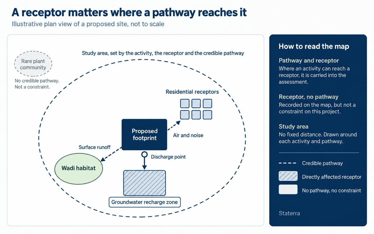
The mapping only earns its keep if it tracks pathways as well as receptors. A rare plant community a kilometre from a proposed footprint isn't automatically a constraint on the project; a shallow groundwater recharge zone sitting directly beneath a planned discharge point is. The value of the exercise comes from linking each receptor to the specific route by which a project activity could reach it, not from producing a list of everything nearby. There is no universal distance threshold. The study area is defined according to the project activity, the receptor type and the credible pathway through which an impact could occur.
This isn't a Staterra invention. The IFC Performance Standards on Environmental and Social Sustainability and the IAIA Principles of Environmental Impact Assessment Best Practice both call for early identification of receptors and robust baseline assessment, run through the full planning process rather than bolted on once a layout is fixed. Sensitive Receptor Mapping is the practical, spatial expression of that principle.
What's actually out there?
The value shows up differently depending on what's being protected.
Biodiversity. Mapping identifies habitats, protected areas, biodiversity hotspots, wildlife corridors, and general ecosystem sensitivity, giving a conservation-aware starting point for site and layout decisions rather than a retrofit once construction is already planned. The IUCN Red List of Ecosystems Guidelines (2024) now gives this a consistent classification framework to work from.
Air quality and noise. Before AERMOD or SoundPLAN can model anything meaningful, they need to know what they're protecting. Receptor mapping identifies the residential areas, schools, healthcare facilities, and ecological receptors that dispersion and noise modelling need to account for, and does it early enough to shape mitigation rather than just measure impact after the fact.
Water resources. Surface water bodies, groundwater recharge areas, and drainage networks are mapped alongside the rest, flagging where physical disturbance or contamination risk needs particular care.
From satellite to sensitivity map
Staterra's approach runs in three stages. First, environmental data collection and integration: reviewing existing environmental information, regulatory requirements, and available spatial datasets, and folding in ecological baseline surveys and field observations rather than relying on desk data alone.
Second, GIS-based mapping in ArcGIS, building sensitivity maps that classify biodiversity receptors, protected areas, residential receptors, water resources, and other ecologically sensitive areas. Third, integration with the modelling tools that carry the assessment forward, AERMOD for air quality, SoundPLAN for noise, so the receptor map isn't a static output but an input the rest of the EIA actually uses.
Inside a live industrial site
On a recent redevelopment and expansion of an onshore oil and gas processing facility in the Eastern Province, this approach shaped the EIA from the outset.
Redevelopment sites carry a complication greenfield sites don't: the receptor map has to separate what's already affected by the existing facility's baseline operations from what would be newly affected by the expansion, or the assessment ends up attributing existing conditions to a project that didn't cause them.
Sensitive receptor mapping ran as a core thread through the assessment, feeding the ecological survey work and the air quality and noise modelling that followed, and giving the permitting submission a spatial, evidence-based basis for its mitigation planning rather than a generic one. Greenhouse gas emissions modelling ran alongside this work, drawing on process and operational data rather than the receptor map itself. Client confidentiality limits how much of the detail can be shared here, but the pattern held: receptors mapped early meant fewer surprises later.
Timing is the whole method
Sensitive Receptor Mapping enables early identification of environmental constraints, improving project planning, reducing environmental risks, and supporting more robust Environmental Impact Assessments. The earlier it happens, the more it can actually change, which is the whole point of doing it before the drawing board decisions are made, not after.
If your project is still choosing a site or finalising a layout, that's the moment to map what surrounds it, not after the decision is made. Talk to Staterra's EIA team before that window closes.
Author: Rawan Alsirhani - Associate Consultant, Environmental Services, Staterra
Let's discuss your project challenges
Our team supports clients with practical environmental insight from planning through delivery.
Contact us
Our Latest Posts

Protecting what's below: groundwater contaminant transport modelling for petrochemical capacity expansion in Jubail Industrial City
When a petrochemical facility in Jubail Industrial City undertook a significant debottlenecking programme to increase production capacity, the project triggered a critical environmental obligation: demonstrating, with technical certainty, that the expansion would not compromise groundwater quality...

Environmental Modelling as a decision-support tool for impact assessment
You're trying to assess the environmental impact of a project that involves dozens of interacting variables – emissions, drainage, wind, terrain, receptors, land use, and operational scenarios. Looking at each one in isolation won't give you the answer. It will give you a fragment. That's where...

Your EIA is on the critical path. Don't let it become the bottleneck.
Four facilities. Ninety days. A Category-2 EIA that has to satisfy NCEC, align with SAEP-13, include a Health Impact Assessment, and land a Construction Environmental Management Plan with a dust mitigation component, all before a single upgrade to Dhahran, Qatif, or Al Hasa's fire and oily water...